Jul 24, 2009

no dragon nor sunset!

D & I went for our planned hike (Nam Shan- SLCT-Double Dragon Stream-Sunset Peak-Pak Kung Au) yesterday morning, we took bus 3M to Nam Shan campsite. From there, we hiked an ascending small section of the South Lantau Country Trail to reach the mid-section of Double Dragon Stream. We intended to trek up the rest of the stream to Sunset Peak from this point, but it began to rain and furthermore, we couldn't find any clear indication pointing to the correct path up the stream. After about 45 mins of searching for any visual indication, we still couldn't find it, in the end we decided not to continue. We could have just explored and trekked up the stream, but taking the weather into consideration, we chose not to. We back-tracked all the way to our starting point (Nam Shan) to take the Lantau Trail stage 2 path to reach Sunset Peak @ 869m -Hongkong's third highest mountain instead. It was a steep ascend, after we had strenuously trudged our way up for about 3 1/2 distance post, we noticed that heavy fog has gathered at the peak above! We decided not to take the risk of getting wet and lost up in the mountain, so we back-tracked all the way to Nam Shan again!! From Nam Shan we took the old village path to Mui Wo (via Luk Tei Tong) for our lunch and finally took a bus home.
Looked like this was a 'back-tracking' to 'nowhere' kind of trip! hahaha... surprisingly, we were completely worned out after this trip!
beginning @ nam shan


Jul 20, 2009

dragon and sunset

We'll probably hike another 'combination' trip before the week is out. Uhm.. I am looking at both the Double Dragon Stream and Lantau Trail Stage 2 (via Sunset Peak - Hongkong 3rd highest mountain @ 869m elevation). Let's see how we can combine these two together.
First, we'll take NLB bus No. 3M from Tung Chung to Nam Shan, then hike a small section of the South Lantau Country Trail (towards Pak Kung Au direction) until we hit the middle-section of the Double Dragon Stream on the trail. We'll start from this part of the stream (approx. at 260m) and trek up the rest of the stream which ends at about 525m where we will hit Lantau Trail Stage 2 near Sheung Tung Au, from there we will hike to Yi Tung Shan and then to Tai Tung Shan aka Sunset Peak. To end this hike, we will most likely continue on Lantau Trail Stage 2, the easy way out (from Sunset Peak to Pak Kung Au on Tung Chung Road).
Besides the exit at Pak Kung Au, there are two other alternative ways we might consider, one is to back-track to Sheung Tung Au (after visiting Sunset Peak and all the unique stone houses) and take the tedious 'knee-breaking' 2.3km Wong Lung Hang Country Trail all the way down to Wong Lung Hang Road (from 690m descend to 80m). Two, a less trodden, nonetheless tedious way is to take the 'unofficial' (definitely with overgrown vegetation) footpath (hopefully one can find it) from Sunset Peak(869m) to Shek Sze Shan(338m) , then to Wo Liu Tun(324m) and finally exiting near Lung Tseng Tau Village. These two ways sound really tough! We'll give it some serious thought before venturing into it. Till then!

Jul 16, 2009

man cheung po

We did it! D & I completed the combi-trip today. We took NLB no.11 to Tai O, alighted at the bus terminal and walked across the bridge at the new promenade near the bus terminal. We passed through Nam Chung village & Fan Kwai Tong village and then it was concrete path by the coastline all the way until we reached Yi O beach. (This is part of the Lantau trail stage 7).
We tried to locate distance post L060, but none was in sight, for we needed to make a left halfway past this L060 post. We had no choice but to estimate the distance. Thank God, in the approximate vicinity, we managed to spot some ribbons (left by previous hikers) tied to the branches at the entrance of the path uphill. We gave it a shot. My gosh! This uphill climb wasn't easy for me, at some parts of the path, we had to bash through overgrown bushes and some even reached up to my head. All the spiders in Hongkong must have congregated on this path for their summer camp!! hahaha there were zillions of them! D had to do the men's thing and cleared the path for me! : ) Still, at one point a stray strand of spider web got into my mouth... yucks! I was thankful it wasn't the spiders though!! ;) By the time we emerged from this primary forest, I was pretty exhausted. This path led us to a pool/dam which they named Heaven's pool. We took some photos and continued our way up to Man Cheung Po main waterfall. The 70m high Man Cheung Po waterfall is beautiful. It is one of the nine most famous waterfall in the whole of Hongkong. After taking some photos, we took the forest path on the right of the waterfall up to Nose Mucous waterfall (I know..what a name, isn't it!). Oh my! The climb was really challenging, I had never climbed anything so steep and for such a long way up before... I almost had a cramp in my right calf. We took a short break at the Nose Mucous waterfall, had some snacks... and it was back to more climbing again! After reaching the Nose Mucous waterfall, I thought there will be minimal steep climbing for the rest of the journey, but on the contrary, we had to climb up the forest path on the right side of the waterfall and then continued climbing up to the peak of a pyramid hill (located right after Nose Mucous waterfall) just to get to the exit of this stream. Thank God the weather was good during this period of climb.
At the top of this pyramid hill, we hit the footpath that led us to Man Cheung Po campsite. After passing by the campsite, we visited Lung Tsai Ng Yuen. It's a hit or miss with this place, sometimes it is open, sometimes it's not. You get to go in if the caretaker is there cleaning up the place, if it's his day-off... too bad! ;) We managed to go in and had a quick look around and took some photos of the place. Frankly, the place is pretty rundown and the bridge is being barred for safety reasons. What a pity for such a beautiful place! After awhile, we left this sad place and went back to Tai O for some iced milk tea and yummy sandwiches. It perked us up alright. The whole journey took us about 4 hours excluding the bus ride both ways. Overall, it was a good and challenging trip, more so than expected. I really worked those 'muscles'! Also, just a note, we weren't tempted to take a dip in the pool at all ..... the water was not as clean as what we were accustomed to... (we were being pampered by the unpolluted water from the five dragon streams), so we didn't have the desire to go into the pool.
Warning: The last part of the journey down to Tai O ( after Lung Tsai Ng Yuen) entailed a really steep and never-ending descent, please wear your kneeguard, you might just need it! hahaha
 
scenery below heaven's pool
heaven's pool
Man Cheung Po waterfall
Nose Mucous waterfall
an unknown waterfall
an unknown pool behind the pyramidal hill
beautiful scenery from the top of pyramidal hill
Lung Tsai Ng Yuen

Jul 14, 2009

planning a 'combi' trip

After 'studying' the map 'intensely' last night ;) , I came up with a 'combination' trip for our next trip.
Tai O > Man Cheung Po > Lung Tsai Ng Yuen > Tai O.
Details:
We'll take a bus to Tai O, walk southward passing the old Tai O saltpan farm? to Nam Chung village. From Nam Chung village, we'll follow the path that hugs the coastline and walk southward, passing by Nga Ying Kok campsite, continue walking ahead. Between distance post L060 and L061, there is a footpath that will lead us to Man Cheung Po. An alternative way to get to Man Cheung Po is to trek up the Shui Lo Cho stream after distance post L061 (the stream runs almost parallel to the footpath, but not quite, I should say running in the same direction?) We'll give the Shui Lo Cho stream a miss and take this short-cut footpath instead. It will save us a lot of time and energy to enjoy the Man Cheung Po waterfalls later. (The climb up Shui Lo Cho stream is difficult!). At the end of footpath, we'll reached a big pool named Heaven's pool, followed by the 70m high Man Cheung Po main waterfall and then the Nose Mucous waterfall. After the Nose Mucous waterfall, we'll take a footpath and continue our hike to the Man Cheung Po campsite and then to Lung Tsai Ng Yuen and after that it's back to Tai O.
Sounds like a pretty 'relaxing' hike doesn't it? I can't wait to do it! Let's pray for lovely weather, strength and Daddy God's protection on this trip. :) Ciao!

Jul 10, 2009

more drakontas!

I just found out on the internet regarding those streams that we came across while hiking the South Lantau Country Trail two days ago, just to name a few, they are South Dragon Stream, Green Dragon Stream, Green Dragon Left Offshoot, Middle Dragon Stream, Middle Dragon Left Offshoot and Double Dragon Stream. Interesting! Now I have more streams to add to my TO DO list! haha!
Probably we'll try the Double Dragon Stream or the Green Dragon Stream in the near future, though I am considering the supposedly easier Pak Mong Stream or the West Dragon Stream first. Anyway, we shall see. How I wish I have some like-minded friends who are really interested in stream-trekking, so that I can get to discover and trek more streams more often or more intensively. Too bad it's not safe to do it alone........not advisable......or else.......hmm...

Jul 8, 2009

lovely trail! South Lantau Country Trail

overlooking Chi Ma Wan peninsular

D & I hiked the South Lantau Country Trail this morning, from Pak Kung Au to Nam Shan, 7km in distance with official time of 2 1/4 hours, but it took us a total of 3 hours which included breaks and lots of photo-taking. It was such an enjoyable trip and the weather was great! Thankyou Lord! The trail crossed many streams and waterfalls. The waterfalls are simply lovely, and there are quite a number of them! What a pleasant surprise indeed! For a moment I thought I was stream-trekking! haha I reckoned this is a good trail for beginners to train for stream trekking! The paths are uneven dirt road with stones and rocks, which required some skills to negotiate. Proper footwear is highly recommended (we wore our trekking boots). The trail has a very back to nature feel, no proper cement road in sight and it was also full of spiders and webs....Perfecto! : ) I love it (not the spiders though) ! This is a trail that I wouldn't mind hiking again in the future if I wanted something simple, natural and with lovely waterfalls. A thumbs up for today's hike!


Jul 6, 2009

country trail? anyone?

As the weather forecast looked promising for the next few days - SUNNY. D suggested we go for a hike on either Wed or Thur. As he is still recovering from his injuries from our last stream-trekking trip, we decided to take it easy and do the supposedly easy South Lantau Country trail. We will not be hiking the whole 10.5km trail, but instead, we'll just hike for about 7km from Pak Kung Au (on Tung Chung Road) to Nam Shan (near Mui Wo). We estimated that we'll probably need 3 hours or less. I gathered from the information on the internet that this is a relatively easy hike- level 2, and it's suitable for older children. Well, we'll find out! .... till then! Ciao!

Jul 4, 2009

north drakontas! perfect weather & a great trip!

I had the most enjoyable trip yesterday!! D & I trekked the North Dragon Stream along with Becky and her friend Sarry. It was a 440m ascend with exit on Pok To Yan mountain. It took us a total of about 7 1/2 hours to complete the whole trip from the start of Wong Lung Hang Road to the finish at Fu Tung Estate. We actually estimated it to be a 3-5 hrs trip, but because Sarry was a first timer, we needed more time. Before the trip, I informed Becky that this was going to be a very challenging trip (for our level of fitness and expertise) and neither D nor I have attempted it before. Last minute she asked her friend Sarry to come along, I asked her if her friend is able to handle this trip. She replied saying that if her friend is unable to handle this trip, she would leave us and go back on her own.....I bought it....

Enroute, Sarry was stung by some insects (which turned out to be okay after applying some medicated oil), she wanted to turn back & go home. I guess Becky was caught in the middle. In my own ability, it is more difficult to trek down a stream than to trek up. Anyway, at that point of time, the decision was up to them. If Sarry had decided to go back, Becky might go with her, but D & I would not be affected (that was the idea I gathered on the phone from Becky in the morning!) In actual fact, I would have felt uncomfortable letting them go back by themselves, but on the other hand, I wouldn't want my trip to be ruined! I was torned in between initially when Sarry said she wanted to go back! (Of course, this trip will be aborted without second thought if there is a life-threatening situation) . But in this case, after evaluating the situation and Sarry's condition, I stood my ground on continuing my way up the stream. Thank God for His grace, Sarry was kind of 'willed' by Becky to continue the trip... hahahahaha brilliant! And so we merrily made our way upstream. (Of course with loads of whinning from Sarry to the point where we were immuned to it & D had to escape as far as possible! hahahaha .... we turned a deaf ear to her, seeing that she did not have any real problem climbing! In fact, in my opinion, she was doing quite well. ) Sarry had been doling out phrases like, 'I"M SO SCARED! I"M SO TIRED! I CAN"T CLIMB THIS! I WANT TO GO HOME!" whine whine whine like a broken record since the beginning of the journey to the end of the trip! Guess after awhile, it became like white noises to us! ~Thanks Becky!~ ;) We teased Sarry about it at dinner and we all had a good laugh! ^_^ Overall, Sarry did a great job for a first-timer, she was able to complete the whole journey despite her whinning. Well done!
As for Becky, boy! Can she climb! Spiderwoman! I wondered how she managed to climb up that particular tight spot/big boulder at the waterfall without assistance! I am amazed!

pool with crystal clear water, lovely!

Overall, It was a great trip for me. I was able to challenge myself many times on all the climbing of the steep slopes, waterfall and some very tight spots which normally I would find it impossible to climb! Stream-trekking is a physically demanding and mentally challenging sport, it builds confidence and endurance. I had a good workout indeed! Thankyou Lord! I truly enjoyed it and it was a very fruitful trip for me. Oh and one thing which I mentioned many times with thanksgivings to the Lord on the trip. " The weather is ABSOLUTELY PERFECT!" God is good! We prayed for perfect weather and we got it! Hallelujah!


Casualties on this trip:

Becky - Fell on her 'pet pet' on her descend to Tung Chung on Por Kai San, small cut on finger, LOADS of blood donation to the Mosqui World Blood Bank. Did I miss out anything?

Sarry - stung by swarm of unknown insects (she stuck her face right infront of the insects' nest?! ), small cut on finger, sore heel due to new shoes, mosquito bites? How on earth did she tear the gloves at the fingertips? Note: Please do not apply anything with fragrance on hiking trips, you'll attract unwanted 'admirers' like you did on this one! (bees....and insects...)

D - Fell and scraped his legs quite badly, worst sites, his right hamstring & calf. Swollen palm-when he tried to use his hands to cushion his fall. Felt giddy from the fall, had to make him sit down and recuperate before proceeding.

Me - 3 mosquito bites, one on the face, one on the left arm and one oops! on the butt! Some sandflies bites on the feet before I remembered to apply insect repellent. Some minor abrasion on the arms and that's about it. I came out pretty unscathed this time. (Unlike my last stream-trekking trip, I had a major contusion on my right calf with open wounds- being hit and scraped by a loosed large rock.)

Overall, it was a very blessed trip for me, challenging yet rewarding. Thankyou Lord for giving me strength! ;) Ciao for now!


P.S. Thankyou D for taking up the task of opening the way for us (by checking things out and getting rid of loads of big spiders and their webs etc..) And also for stopping and helping the 3 of us at really tight spots and hauling us up twice when we really needed it. Hope your already compromised arms are okay! I appreciated your help. I am obliged to defend you on this one because you were being jested of disappearing and not helping the 'damsels in distress'! Which are feigned distresses most of the time! haha Thankyou! You did a great job. Pardon their oops! I mean our expectation of you to be at our beck and call! ;) You can't be in the front and the back at the same time! Lastly, a big Thankyou to you my darling!
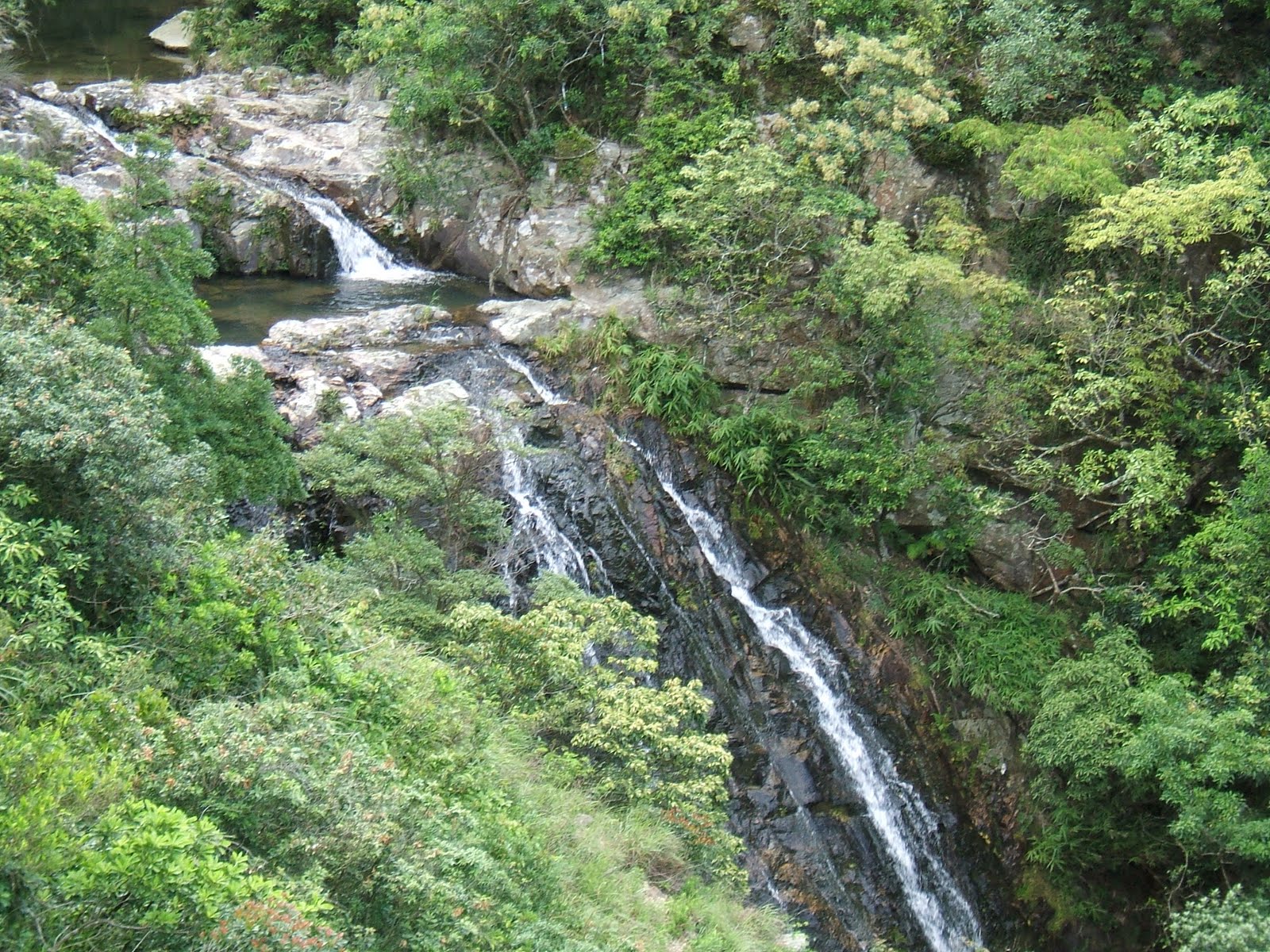
Note: north dragon stream has a 3 1/2 star difficulty rating (the most difficult being 5 stars). Exit from this trek is at the top of this cliff below (The highlight of this trip) named 'Cliff of Celestial Book' @ elevaton of about 440m on Pok To Yan Mountain.
cliff of celestial book
scenery from the exit on Pok To Yan mountain
Descending on Por Kai San mountain overlooking Caribbean Coast Estate